
What are hardiness zones?
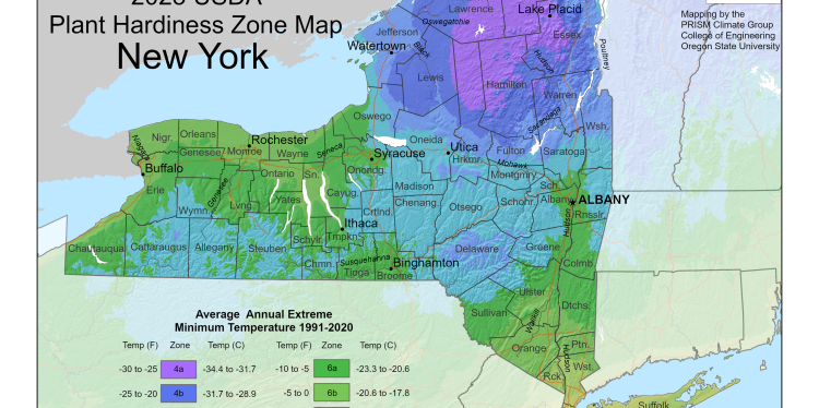
Hardiness zones are geographic areas that are defined by their average annual minimum temperature, and they can help gardeners figure out which plants are likely to thrive in their gardens. They are a standard defined by the U.S. Department of Agriculture, which uses GIS (Geographic Information System) data spanning 30 years to determine the zones.
Across the U.S., there are 13 hardiness zones, and each zone represents a 10-degree variation from the adjacent areas. Some zones are further divided onto a or b subsets, often reflecting elevation differences or the presence of modifying bodies of water, such as the Great Lakes.
In Orleans County
Most of Orleans County falls within zone 6b. We generally experience winters with the lowest temperatures ranging from -5 to 0 degrees Fahrenheit. That hasn’t always been the case, as data shows our environment is changing. From 2002 to 2023, we were considered zone 6a, with average minimum temperatures between -10 and -5 degrees. In 1990, we were considered zone 5b, with average minimum temperatures between -15 and -10 degrees.
Be aware that this warming presents welcoming conditions for pests and diseases to expand their territories, causing gardeners to continue to adjust and modify their control measures.
It is also worth remembering that because hardiness zones are based on average minimum temperatures — not the lowest-ever temperatures — we could still experience an extreme cold snap that could damage plants that would normally survive our winters. While there may be much discussion about climate change, gardeners are most successful as they use the information available in planning our gardens.
You can find the USDA Hardiness Zone map online.
Master Gardener Volunteer Column